Is there any tool more useful when it comes to land stewardship than a good map? Maps come in all kinds of formats and answer all kinds of questions. Chances are, if you’re wondering about something, there’s a map for that.
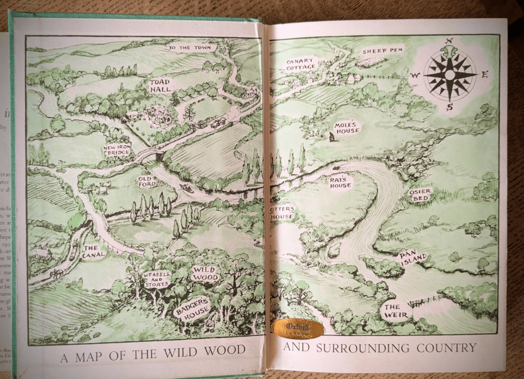
Land stewardship sits somewhere between science and story. As a child, I loved the books that came with a map pasted into the front cover — The Hobbit, the Narnia books, Wind in The Willows . . . They all began with a map.
When it comes to land stewardship, maps are different ways of collecting and telling the land’s story. They’re tools that can take us back in time, can tell us what’s happening right now and can project into the future. Some maps are very intricate, provide an incredible level of detail and require technical/professional expertise. Some maps get scratched on cocktail napkins. Whatever you think about maps, however much experience you’ve had – or haven’t – the right map for the right question can be a land steward’s best friend.
Technical Nerd-Level Maps
Let’s start with the technical maps. These are maps that require specialized equipment, software, or professional certification. They may cost some money, they’ll definitely cost time, but for anyone who takes the time, these maps deliver skills and options. Let’s get into it.
1. LiDAR Terrain Mapping (Airborne or Drone-Based)
LiDAR is a way of measuring the land from above using tiny pulses of light.
An aircraft or drone flies over your property and sends millions of quick flashes downward. The time it takes those flashes to bounce back tells the computer exactly how high or low every point on your land is. LiDAR’s specialty is detail.
And when I say detailed, I mean detailed enough to see:
- Subtle dips where water gathers
- Old drainage paths you didn’t know existed
- Slight ridges that dry out first in summer
- Gentle slopes that look flat to the eye
From that one flight, specialists can create different kinds of maps, such as:
- A map that shows the true shape of the ground, with trees and buildings digitally removed
- A map that shows the ground plus trees and shelterbelts
- A shaded image that makes hills and hollows easy to see
- A map that shows which slopes face the sun and which stay cool
- A map that predicts how water will flow after a heavy rain
This kind of mapping is especially useful if you are:
- Planning water movement (swales, berms, dugouts, drainage)
- Trying to understand erosion
- Restoring wetlands or riparian areas
- Designing roads, corrals, or building sites
- Making decisions where inches actually matter
Can you get this for free?
Sometimes.
In Alberta and across Canada, government agencies have flown large areas and made the information publicly available. The data exists — but it can be technical to work with. You may need someone who knows mapping software to turn it into something readable and useful.
Free sources often include:
- Federal elevation datasets through Natural Resources Canada
- Provincial portals through the Government of Alberta
- Biodiversity mapping projects like the Alberta Biodiversity Monitoring Institute
When would you hire someone?
You might hire a geomatics or survey company if:
- Your area hasn’t been mapped yet
- You want more detail than the public data provides
- You need the information for engineering or regulatory purposes
- You want someone else to interpret it and give you clear, ready-to-use maps
If your project involves legal boundaries or certified survey work, you would need a licensed professional through the Alberta Land Surveyors’ Association.
Free sources (Alberta / Canada)
- Natural Resources Canada – CanElevation / HRDEM datasets
- Alberta Biodiversity Monitoring Institute – public LiDAR releases
- Government of Alberta GeoDiscover portal
Free data exists in many areas — but you may still need someone to process it into steward-friendly products.
2. Legal Land Surveys
If you need:
- Boundary clarification
- Subdivision
- Easements
- Encroachment verification
This is not DIY.
You need a licensed land surveyor.
In Alberta, that means a professional registered through the Alberta Land Surveyors’ Association.
3. Professional Topographic Surveys (Engineering-Grade)
More detailed than basic mapping, these are used for:
- Building placement
- Drainage design
- Road construction
- Pond construction
- Regulatory approvals
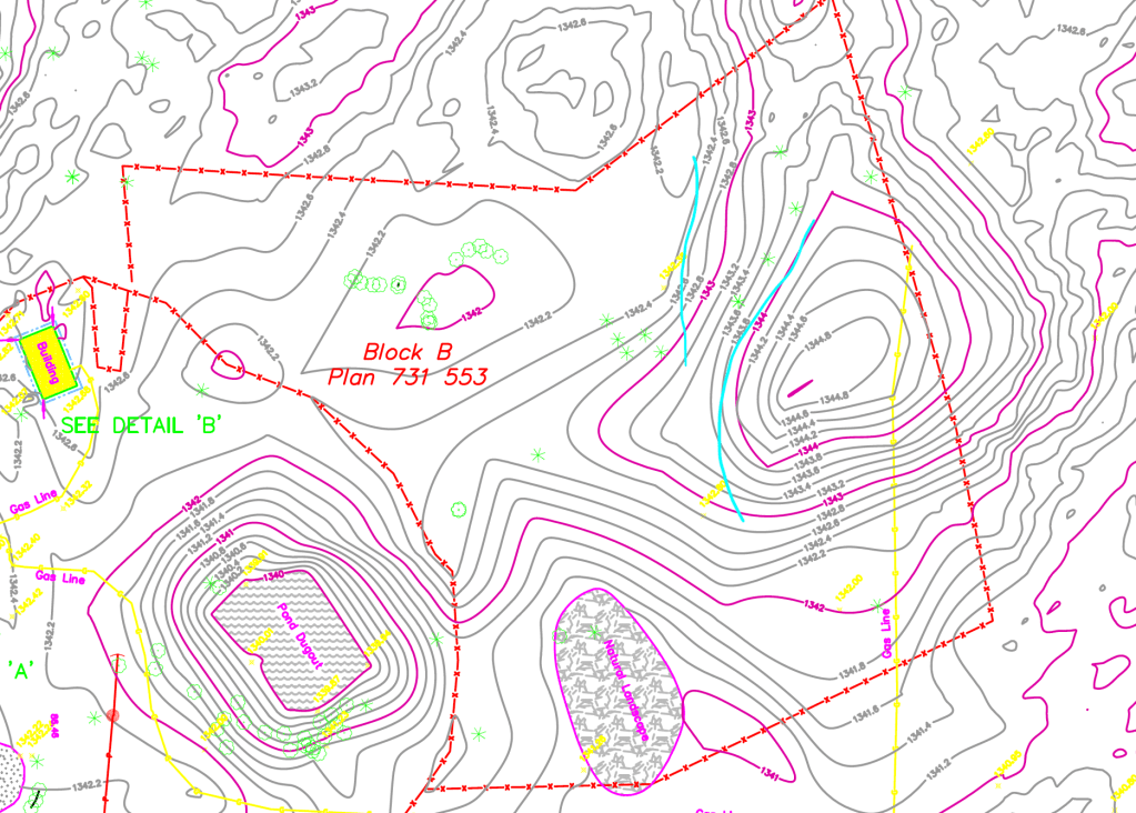
This is a topographical map we had done very early into our tenure here at the homestead. Things have changed somewhat but this map continues to play a role in my land planning. The aqua coloured lines in the upper right quadrant represent a berm project I’m considering.
They often combine:
- RTK GNSS – this is a very precise GPS tool that can be accurate down to inches. The GPS on your phone, by contrast, can be off by several feet.
- Total station – this looks like a telescope on a tripod. It’s often used for contour maps (as above) and can measure angle, elevation and distance.
- Drone photogrammetry – this is mapping-by-photos. Think Google Earth.
- LiDAR – which you already know about! You clever thing, you.
This is the map you commission when you want to make sure your neighbour’s fence is on his side of the property or that a potential water management strategy is going to do what you want it to do.
4. Soil Surveys & Professional Testing
Provincial soil maps are publicly available, but high-resolution site testing requires:
- Lab analysis
- Possibly an agrologist or soil specialist
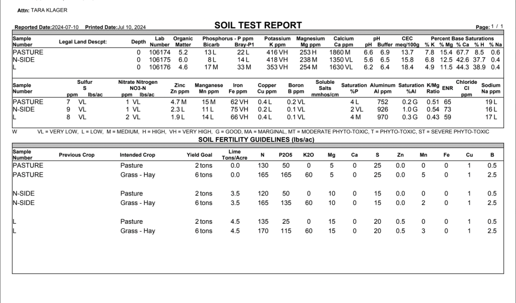
This is a copy of a soil test I had done a few years ago as part of our Animal Welfare certification (for more on that, you can read this). You can see all the various measurements the lab took using a variety of testing methods.
These maps answer:
- Texture – the size of the soil particles. Sand has large particles and water will drain quickly. Silt is mid-sized, it feels silky when it’s wet and clay has teensy particles and it’ll hold water until the sun bakes it dry. Texture tells you how your soil handles water and roots.
- Salinity – this is dissolved mineral salts in the soil. Higher levels can make it hard for plants to absorb water and decreases germination.
- Organic matter – The higher it is (within reason), the more buffered and forgiving your land tends to be.
- Nutrient profile – This is what’s actually available for plants to eat. Too little and growth suffers. Too much (especially from repeated inputs can cause other problems.
- Limitations – Every soil has built-in constraints. Things like erosion risk, compaction, low organic matter or high salinity. Or, as in our case, a very thin layer before you hit rocks – lots of ’em. Limitations tell you what your soil will struggle with, no matter how much optimism you bring to it.
5. Hydrological & Wetland Delineation Mapping
If wetlands or regulated water bodies are involved, mapping may require:
- Qualified wetland professionals
- Environmental consultants
- Engineers
This is not just ecological — it can be regulatory.
Maps you can make
These are the ones that build stewardship instincts. Instead of instruments and other kinds of expertise, for these kinds of maps, often all you need is some attention, some time and a way to record your observations. These maps are built slowly, season by season.
(If you’re not sure how to “look” at land, or what kinds of observations will be useful, take a look at our Homestead Field Guides. They’re arranged around the seasons and can be a useful tool as you learn this stewardship discipline.)
1. Vegetation Map
Divide your land into zones and record:
- Dominant grasses
- Native vs tame
- Forbs
- Shrub regeneration
- Bare soil
You can do this with:
- A printed aerial photo
- A pencil
- A clipboard
Repeat yearly. Watch succession.
2. Grazing Pressure Map
Mark:
- Date grazed
- Duration
- Stock density
- Recovery days
This becomes your management memory. If you’re not sure about what a grazing pressure map might look like, take a read through our Adaptive Multi-Paddock Grazing Field Notes! There’s a lot of information there that will help you get started.
Remember, maps don’t have to be “drawings.” They can be sketches, paragraphs, photographs or any representation of the information you’re observing. Build a map that works for your brain, your memory, your land and your skill set. You can refine over time!
3. Microclimate Map
Have you ever walked through a yard, a pasture, a field or any other outdoor space and encountered a temperature change? Congratulations! You may have just stumbled into a microclimate! For these maps, mark:
- Frost pockets
- Early green-up slopes
- Wind corridors
- Snow drift zones
- Shelter pockets
In chinook country, this map is gold.
4. Wildlife Map
Mark:
- Nesting sites — don’t forget to look up AND down. On one occasion while I was wandering through a pasture, a Wilson’s Snipe nesting pair exploded from the ground just in front of me. I about jumped straight into the arms of Jesus.
- Game trails — wandering ungulates, foxes, coyotes, God-help-me-bears and more.
- Burrows — pocket gophers! Voles!
- Pollinator corridors — whither goeth the bugs and butterflies, so goeth the map!
- Owl sightings — a common one for us.
- Crane sightings — a new one for us!
This shifts you from production mindset to ecosystem mindset.
5. Story Map
Where did:
- The first clover return?
- The soil soften?
- A ewe lamb unassisted?
- A berm finally hold?
This is not sentimentality. It is achievement, it is movement, it is evolution – for both land AND steward! It is pattern layered with memory.
A Final Word
Technical maps give you precision while DIY maps give you intimacy. I try to use both when I can and I am shameless about asking for help when I need it. Remember, you don’t need to be an expert land steward — you need to be an expert on YOUR land. Context is everything. After all, a laser can show you a drainage swale but only walking it — day after day, season after season — will teach you how it lives.
This is a Tending post — a practical look at our tools, methods, routines, and on-the-ground decision-making. It’s not a one-size-fits-all how-to, and it isn’t meant to substitute for local knowledge or professional guidance. It’s just what we’ve found useful and what we’re doing here on our farm, in our conditions, with our sheep (and alpacas), written down plainly in case it helps. For more about why we do things the way we do them, the philosophy that informs our process, you’ll find those posts in Living.


Leave a comment